Environmental management of the Bagmati River Basin
The Bagmati River is the principal river of the Bagmati Basin (ca. 3640 km2) in central Nepal. The river, fed by springs and monsoon rainfall, originates in
the north of Kathmandu Valley (the capital of Nepal) and drains across the
Mahabharat Range to the Gangetic plain. The Basin transacts three distinct
latitudinal physiographic zones (Mountain, Siwalik and Terai) of the Nepal
Himalayas. Hard rock geological formations at the Basin headwaters stand
out as a resistant ridge complex compared to the weak and fragile rock
formations at the middle stretches of the Basin.
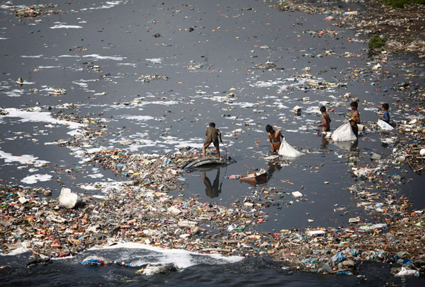
The Bagmati Basin currently faces a number of serious environmental and
ecological challenges. Urbanization and industrialization of the Basin
headwaters at Kathmandu contributed to water quality deterioration with
regional consequences on the aquatic ecosystem and on the health of the
downstream sub-basin’s user groups. Increasing population pressure on the
fragile mountain slopes has also resulted in the rapid degradation of the
natural resources.
As a consequence, deforestation, soil erosion, landslides,
siltation etc. are occurring in the upper and middle sections whereas
sedimentation and flooding is frequent in the lower stretches of the
watershed. This synergetic effect is of concern for the sustainable use of the
resources and infrastructures.
The overall damage caused by the 1993 flood in the Basin has provided
impetus to Nepalese planners, engineers, environmentalists, policy makers
and stakeholders to think on the Basin-wide environmental perspectives for
the overall sustainability of the project. This paper deals with the various
facets of environmental management and monitoring of the watershed for
its sustainable development.
The Bagmati River originates just below the summit of Shivapuri Hill and is
fed by springs and monsoon rainfall and a number of tributaries as it flows
down from the Kathmandu valley floor and passes through the valley at
Chovar. The river is fed by a number of tributaries originating at
Mahabharat and in the Chure Range before it reaches the Terai at Karmaiya.
The Bagmati River Basin, based on morphology, land-use etc., can be divided into different sub-basins viz. Upper Bagmati, Upper Middle
Bagmati, Lower Middle (Terai) Bagmati and the Lower Bagmati (Terai) sub-basin. The total area of the Basin within Nepalese territory is about 3638km2.
In the 1991 census, the total Basin population was given as 1.6 million of
which 61.5 per cent inhabit the Upper Bagmati sub-basin, where the capital
city of the Kingdom of Nepal, along with other four municipalities including
a number of village development committees, are situated. It is also reported
that a total of 2174 out of 4271 water polluting industries operating in the
country are now in operation in the Upper Bagmati sub-basin.
Increasing degradation of the Bagmati Basin has been evident in recent years
due to rapid population growth and expansion of the urban areas within the
upper Bagmati sub-basin. Uncontrolled disposal of untreated wastewater
(domestic, industrial, solid waste leachate, agricultural runoff etc.) in the
rivers has far surpassed the assimilative capacity of the river. Likewise,
deforestation, soil erosion and landslides have been causal factors of Basin
degradation which is being increasingly threatened by damage to the
infrastructure of reservoir, barrage, canals, bridges and roads from debris,
tree and logs carried by the river during the monsoon season.
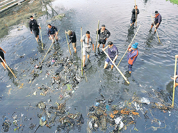
A comprehensive environmental study of the Bagmati River Basin was
carried out by the Water and Energy Commission Secretariat using a team of
experts to formulate concrete proposals for mitigation measures for:
• pollution abatement and improvement of the river water of the river
thereby enhancing its assimilative capacity;
• decreasing suspended solids and siltation in river beds, canals and
irrigated fields; and to
• minimizing threats to the stability of infrastructures.
The concept of Basin-wide planning for sustainable development is still new
to Nepal. A development programme based on, and implemented by,
administrative units could not handle and foresee the environmental
impacts in the surrounding vicinity. A basin is a land unit defined by the
natural barriers and the natural resources within such boundaries have
intricate relationships. Exploitation of one resource has a direct impact on
the other. The study was intended to evaluate the environmental conditions
of the existing Bagmati River Basin in order to help in the appropriate
selection of development projects for the Basin development in a sustainable
manner.
Read full text...
Arjun Paudel
Senior Divisional Engineer
Department of Water Supply and Sewerage
HMG, Nepal
GPO Box 7301 Kathmandu NEPAL
By:
www.unep.ch
Photo:
Google Search